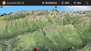
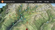
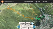
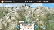
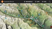
Cauterets Été 3D is an innovative hiking guide tailored for outdoor enthusiasts seeking to explore the picturesque trails around Cauterets during the summer. The app provides a dynamic 3D representation of hiking routes, which enhances planning and navigation experiences. With user-friendly features such as intuitive controls, aerial views, and a 3D compass, this platform is particularly useful in areas with low visibility.
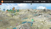
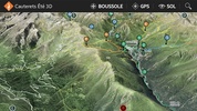
Delve into the adventure with detailed descriptions of 16 notable trails, from the serene Greenway of Gaves to the challenging Refuge Wallon. It offers invaluable insights with photos and information on lakes, barns, and shelters that adventurers may encounter. In prioritizing safety, users are encouraged to study unmarked or off-trail paths, adhere to safety guidelines, and consult mountain guides for organized outings.
The comprehensive offline functionality allows for GPS location tracking relative to the 3D terrain, even when internet connectivity is unavailable. Switch to compass mode for orientation with manual movement, or use the automatic north alignment for hands-free navigation purposes. The aerial views and realistic floor illustrations provide an accurate and immersive visual representation, optimized for the capabilities of your device.
As adventurers embark on both standard and off-trail excursions, they have the option to import GPX tracks for a tailored hiking experience. A physical 3D map can also be requested at the local tourist office for an enhanced reference. Whether one is an avid hiker or simply enjoys occasional walks, the game is an indispensable tool for an immersive and enriching experience through the magnificent landscapes of Cauterets.
Requirements (Latest version)
- Android 3.0.x or higher required

Comments
There are no opinions about Cauterets Été 3D yet. Be the first! Comment